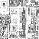
Taipei has been my home for many years. When I arrived I didn't know any Chinese, couldn't read the bus system, and the roads were a little too intense for any cycling or driving. The MRT made exploring Taipei possible! This entirely hand drawn map celebrates what a fantastic system the city has. Even though these days I cycle and drive a little, I still regularly use the MRT as it's often the most stress-free option.
This map covers the entire Taipei system, from Tamsui to Xindian, and Huilong to Nangang. It also presents the city in a way that I don't think has been done before in this style or at this scale. I'm a big fan of the HSR and TRA systems too so I've added those, as well as the Ankang LRT, Maokong Gondola, part of the Airport Line, and part of the Tamsui LRT. This map also stretches into the future with the addition of the new Wanda Line and a couple of extensions.
Given the huge area this drawing covers it also includes a lot of the surrounding mountain ranges and a large part of Yangmingshan National Park, as well as the city's excellent river bike path system.
The map was entirely hand drawn in fineliner pen and digitally colored. I decided that given how much they are a historical part of Taipei's transport system I should color the rivers too!
Print Details
Available as an open edition print in 70 x 50 cm and 85 x 60 cm sizes. The larger size is about 40% bigger than the smaller size and is roughly the size I drew it at. It's easy to find standard frames in either size, although 70 x 50 is slightly easier. The print picture in the listing is the 70 x 50 color version
Delivery within Taiwan is included in the price. The print is printed on matte thick fine art paper. It's a beautiful long lasting print which captures the details well.
If you'd like a combination of features not shown here (for example, night version with just the rivers colored) please get in touch or leave a note with your order, I can make that quite easily.
Product Description
Product Details
- Material
- Paper
- How It's Made
- Handmade
- Where It's Made
- Taiwan
- Stock
- More than 10
- Ranking
- No.19,036 - Home & Living | No.309 - Wall Décor
- Popularity
-
- 9,958 views
- 7 sold
- 27 have saved this item
- Product Type
- Original Design
- Listing Summary
- A detailed hand drawn map of the Taipei area with the MRT and railways
Shipping Fees and More
- Shipping
- Payment method
-
- Credit/debit card payment
- Alipay
- Refunds & Exchanges
- Read more about refunds and exchanges
- Report
- Report this item


